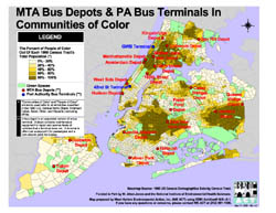
MTA Bus Depots & PA Bus Terminals In Communities of Color
(Click on picture to view as PDF)
Short Description: Locations of Metropolitan Transportation Authority (MTA) bus depots and Port Authority (PA) bus terminals across New York City's Communities of Color by US Census Tract in 1990.
Data Details: The basemap polygons are 1990 US Census Tract boundaries. The green spaces (parks, cemetaries, etc.) were derived from US Census landmark shapefiles. The dataset was derived from 1990 Census Tract demographic data and aggregated to represent all ethnicities of color. Thus, Communities of Color/People of Color includes all ethnicities classified in the demographics data forms as Black, American Indian, Asian, Other, or Hispanic, and excluding White. The legend is classified in equal intervals. The Metropolitan Transportation Authority (MTA) Diesel Bus Depots and Port Authority (PA) Bus Terminals were geocoded by the WE ACT GIS Mapping Specialist. Magnetic north is up.
Credits: Map prepared by Carlos M. Jusino at West Harlem Environmental Action, Inc. (WE ACT) using ArcView® GIS v3.1 software from the Environmental Systems Research Institute, Inc. (ESRI).
Support: Funded in part by the former W. Alton Jones Foundation (now Blue Moon Fund) and by the National Institute of Environmental Health Sciences (NIEHS).
Map Maker’s Notes: A BUS DEPOT is an expanded version of a BUS TERMINAL. A depot contains maintenance equipment that a terminal does not. A terminal is often just a way-point for passengers and a turn-around point for buses.