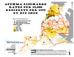
Asthma Discharge Rates Per 10,000 Residents For 1999 By ZIP Code
(Click Picture to view as PDF)
Short Description: Asthma Per Person Discharge (PPD) rates per 10,000 residents by ZIP code for New York City in 1999 in relation to truck routes that allow out-of-state traffic not just local traffic.
Data Details: The basemap polygons are 1990 US Census Zone Improvement Plan (ZIP) Code boundaries. The dataset was obtained from INFOSHARE (Community Studies of New York, Inc., NY), and their Department of Health's (NYCDOH) Statewide Planning and Research Cooperative System (SPARCS) data on asthma rates for residents of all ages in 1999. The legend is classified in quantiles. The New York State inset was obtained from the 1990 US Census state boundaries. The Metropolitan Transportation Authority (MTA) Bus Depots and Port Authority (PA) Bus Terminals were geocoded by the WE ACT GIS Mapping Specialist. The Major Intercity Truck Routes were obtained from the Department of Transportation (DOT). Magnetic north is up.
Credits: Map prepared by Carlos M. Jusino at West Harlem Environmental Action, Inc. (WE ACT) with assistance from the Columbia Center for Children's Environmental Health (CCCEH), using ArcView® GIS v3.1 software from the Environmental Systems Research Institute, Inc. (ESRI).
Support: Funded in part by the former W. Alton Jones Foundation (now Blue Moon Fund) and by the National Institute of Environmental Health Sciences (NIEHS).
Map Maker’s Notes: A BUS DEPOT is an expanded version of a BUS TERMINAL. A depot contains maintenance equipment that a terminal does not. A terminal is often just a way-point for passengers and a turn-around point for buses.