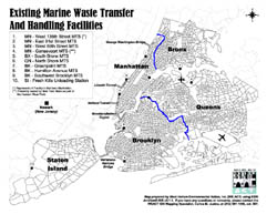
Existing Marine Waste Transfer and Handling Facilities

(Click picture to view as PDF)
Short Description: The locations of existing marine waste transfer stations and handling facilities owned by the Department of Sanitation (DOS) in New York City in 2003.
Data Details: The basemap polygons are 1990 US Census Tract boundaries. The marine transfer stations (MTS) and barge unloading facilities (BUF) were obtained from the Department of Sanitation (DOS). The demarcation lines between Manhattan/Bronx and Brooklyn/Queens were generated by the WE ACT GIS Mapping Specialist. The mapped bridges and tunnels were derived from the US Census street shapefiles. Magnetic north is up.
Credits: Map prepared by Carlos M. Jusino at West Harlem Environmental Action, Inc. (WE ACT) using ArcView® GIS v3.1.1 software from the Environmental Systems Research Institute, Inc. (ESRI).
Support: Funded by the National Institute of Environmental Health Sciences (NIEHS).
Map Maker’s Notes: This map was designed to be reproduced in black and white.
This map was made for the Northern Manhattan Environmental Justice Coalition.
The blue solid line representing the demarcation line between the boroughs of Manhattan and the Bronx is a physical division marked by a body of water (Harlem River).
The blue solid line representing the demarcation line between the boroughs of Brooklyn and Queens is a virtual division marked by local city planning street designations.
The Gansevoort Marine Transfer Station (MTS) in Manhattan is no longer owned by the Department of Sanitation (DOS). It is presently owned by New York State as part of the Hudson River Park.
Although a Barge Unloading Facility (BUF) exists in Staten Island, it is not an enclosed facility. Thus, it is different from an Enclosed Barge Unloading Facility (EBUF).
The airplane over JFK airport faces northeast due to it being an international airport. The airplane over La Guardia airport faces west due to it being a domestic airport.