South Bronx Environmental Scope
(Click picture to view PDF)
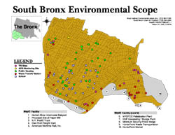
Short Description: The locations of environmentally unfriendly facilities and areas of public housing and education in the South Bronx in 2000.
Data Details: The basemap polygons are 1990 US Census Block boundaries. The locations of Toxic Release Inventory (TRI) sites, Aerometric Information Retrieval System (AIRS) Monitoring sites, Waste Transfer Stations, Schools, and areas of Public Housing were geocoded by Cornell University students from the Cornell University Department of City and Regional Planning. The Bronx County inset was obtained from the 1990 US Census counties shapefile. The green section of the Bronx County inset represents the South Bronx area and its Zone Improvement Plan (ZIP) Codes as derived from the 1990 US Census ZIP Code shapefile. All enumerated facility polygons were created by the WE ACT GIS Mapping Specialist. Magnetic north is up.
Credits: Map prepared by Carlos M. Jusino at West Harlem Environmental Action, Inc. (WE ACT) with assistance from the South Bronx Clean Air Coalition (SBCAC), using ArcView® GIS v3.1 software from the Environmental Systems Research Institute, Inc. (ESRI).
Support: Funded in part by the former W. Alton Jones Foundation (now Blue Moon Fund) and by the National Institute of Environmental Health Sciences (NIEHS).